North American Regional Climate Change Assessment Program
    Home Results Scatter Plots
 
  PROGRAM
About NARCCAP
About Data
Contact Us
  RESOURCES
For PIs
For Users
    Access Data
  User Directory
  Contributions
  Acknowledgements
  RESULTS
Output Data Catalog
General Results
    NCEP-Driven RCM Runs
Climate Change Results
CRCM+CCSM
CRCM+CGCM3
ECP2+GFDL
ECP2+HadCM3 NEW!
HRM3+GFDL
HRM3+HadCM3
MM5I+CCSM
MM5I+HadCM3 NEW!
RCM3+CGCM3
RCM3+GFDL
WRFG+CCSM
WRFG+CGCM3
  SPONSORS
 
Scatter Plots
 

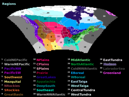
These pages show scatter plots of climate change for each of the Bukovsky Regions, shown above.*

Land regions

Appalachia
CentralTundra
CPlains
DeepSouth
EastBoreal
EastTaiga
EastTundra
GreatBasin
GreatLakes
Mezquital
MidAtlantic
NorthAtlantic
NPlains
NRockies
PacificNW
PacificSW
Prairie
Southeast
Southwest
SPlains
SRockies
WestBoreal
WestTaiga
WestTundra

Water regions

ColdNEPacific
ColdNWAtlantic
Hudson
LabradorSea
WarmNEPacific
WarmNWAtlantic

Compound regions

ArcticAll
ArcticLand
Boreal
Central
Desert
East
EastCoast
GreatPlains
MtWest
NorthernNA
Rockies
South
Taigas
Tundras
WetSouth

Note that these plots use a standard set of ranges for the axes; in a few cases, some points may fall outside the visible plot range.
 
©2007 UCAR   |   Privacy Policy   |   Terms of Use   |   Site Map   |   top of page    
The National Center for Atmospheric Research is sponsored by the National Science Foundation. Any opinions, findings and conclusions or recommendations expressed in this material do not necessarily reflect the views of the National Science Foundation.